
Image: Holland House in an Ogilby map 1675
No higher resolution available.
Holland_House_in_an_Ogilby_map_1675.jpg (356 × 208 pixels, file size: 70 KB, MIME type: image/jpeg)
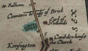
Description: Holland House shown (oriented with west upwards) on John Ogilby's 1675 map of the route from London to Bristol, as "Earl of Hollands". Also visible are a bridge over Counter's Creek and St Mary Abbots church.
Title: Holland House in an Ogilby map 1675
Credit: Britannia Atlas
Author: John Ogilby
Usage Terms: Public domain
License: Public domain
Attribution Required?: No
Image usage
The following 2 pages link to this image:

All content from Kiddle encyclopedia articles (including the article images and facts) can be freely used under Attribution-ShareAlike license, unless stated otherwise.