
Image: Huanghemap

Size of this preview: 800 × 407 pixels. Other resolutions: 320 × 163 pixels | 2,160 × 1,100 pixels.
Original image (2,160 × 1,100 pixels, file size: 94 KB, MIME type: image/png)
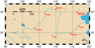
Description: Map of the Huang He and the location of major cities along its course. This map was generated using the Generic Mapping Tools (GMT). The city coordinates (longitude, latitude) used are: 103.6833 36.0500 Lanzhou 106.6833 39.6500 Wuhai 109.9833 40.6666 Baotou 114.3500 34.8500 Kaifeng 116.9600 36.6666 Jinan 108.8666 34.2500 Xi'an 116.4166 39.9166 Beijing
Title: Huanghemap
Credit: From en wiki
Author: Upload by Rolfmueller
Usage Terms: Creative Commons Attribution-Share Alike 3.0
License: CC-BY-SA-3.0
License Link: http://creativecommons.org/licenses/by-sa/3.0/
Attribution Required?: Yes
Image usage
The following page links to this image:

All content from Kiddle encyclopedia articles (including the article images and facts) can be freely used under Attribution-ShareAlike license, unless stated otherwise.