
Image: Hurricane Arthur 2014 United States rainfall

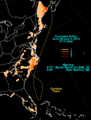
Description: A convective system moving across the northwest Gulf of Mexico sent a mid- level shortwave through the southeast United States. As the shortwave interacted with a frontal zone across the Carolinas, a surface low formed on June 27. The low moved southeast into the Atlantic, though its convection was minimal towards the end of June. On June 30, the low had a well-defined circulation. Late in the day, convection became better organized and the system became a tropical depression that night. Development continued, with Arthur becoming a tropical storm during the morning of July 1 while looping offshore Florida. On July 2, Arthur moved north in the direction of the Carolinas. Hurricane status was acheived early on July 3. Arthur turned north-northeast as an upper-level trough deepened across the East. Becoming a category two hurricane, Arthur moved ashore eastern North Carolina late on July 4 with a well-defined eye. The cyclone weakened after moving back into the Atlantic, with its eye becoming obscured on July 5 while moving south of New England. Vertical wind shear became an increasing issue, with Arthur evolving into an extratropical low on July 7.
Title: Hurricane Arthur 2014 United States rainfall
Credit: http://www.hpc.ncep.noaa.gov/tropical/rain/arthur2014.html
Author: David M. Roth
Usage Terms: Public domain
License: Public domain
Attribution Required?: No
Image usage
The following page links to this image:
