
Image: Hurricane Irma max wind gusts Polk County
No higher resolution available.
Hurricane_Irma_max_wind_gusts_Polk_County.png (389 × 311 pixels, file size: 33 KB, MIME type: image/png)
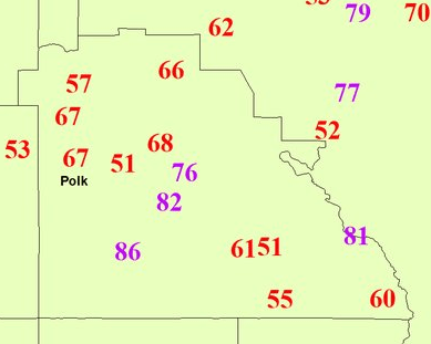
Description: Preliminary top observed wind gusts (miles per hour; 1 mph = 1.6 km/h) during Hurricane Irma in Polk County, Florida. This file was made by the National Weather Service's Ruskin (Tampa Bay) office a few hours after Irma's passage and these preliminary measurements are subject to review, calibration of equipment, and other error corrections. Numbers in purple are hurricane force (74+ mph). Numbers in red are tropical storm force (39-73 mph).
Title: Hurricane Irma max wind gusts Polk County
Credit: Tweet
Author: National Weather Service Tampa Bay bureau (Ruskin, Florida)
Usage Terms: Public domain
License: Public domain
Attribution Required?: No
Image usage
The following page links to this image:

All content from Kiddle encyclopedia articles (including the article images and facts) can be freely used under Attribution-ShareAlike license, unless stated otherwise.