
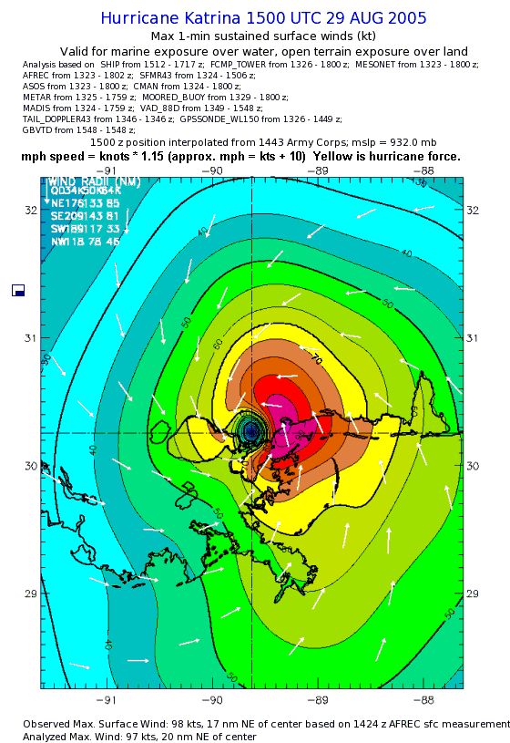
Image: Hurricane Katrina winds 1500utc29Aug05 landfall MS
Description: NOAA Hurricane Katrina windspeed map, for 29 August 2005 at 1500 UTC, the time of landfall in Mississippi (at the Pearl River). The map has an added note about converting wind speed from knots to mph, and has been retouched for clarity when resized smaller.
Title: Hurricane Katrina winds 1500utc29Aug05 landfall MS
Credit: NOAA map image: ftp://ftp.aoml.noaa.gov/hrd/pub/hwind/2005/PostKatrina/0829/1500/col04deg.png (converted to GIF format +mph note, speed bands).
Author: Made using NOAA map
Permission: This image is in the public domain because it contains materials that originally came from the U.S. National Oceanic and Atmospheric Administration, taken or made as part of an employee's official duties. Čeština | Deutsch | Zazaki | English | Español | Eesti | Suomi | Français | Magyar | Italiano | 日本語 | 한국어 | Македонски | മലയാളം | Plattdüütsch | Nederlands | Polski | Português | Română | Русский | Sicilianu | Slovenščina | Türkçe | 中文 | 中文(简体) | +/−
Usage Terms: Public domain
License: Public domain
Attribution Required?: No
Image usage
The following 3 pages link to this image:
