
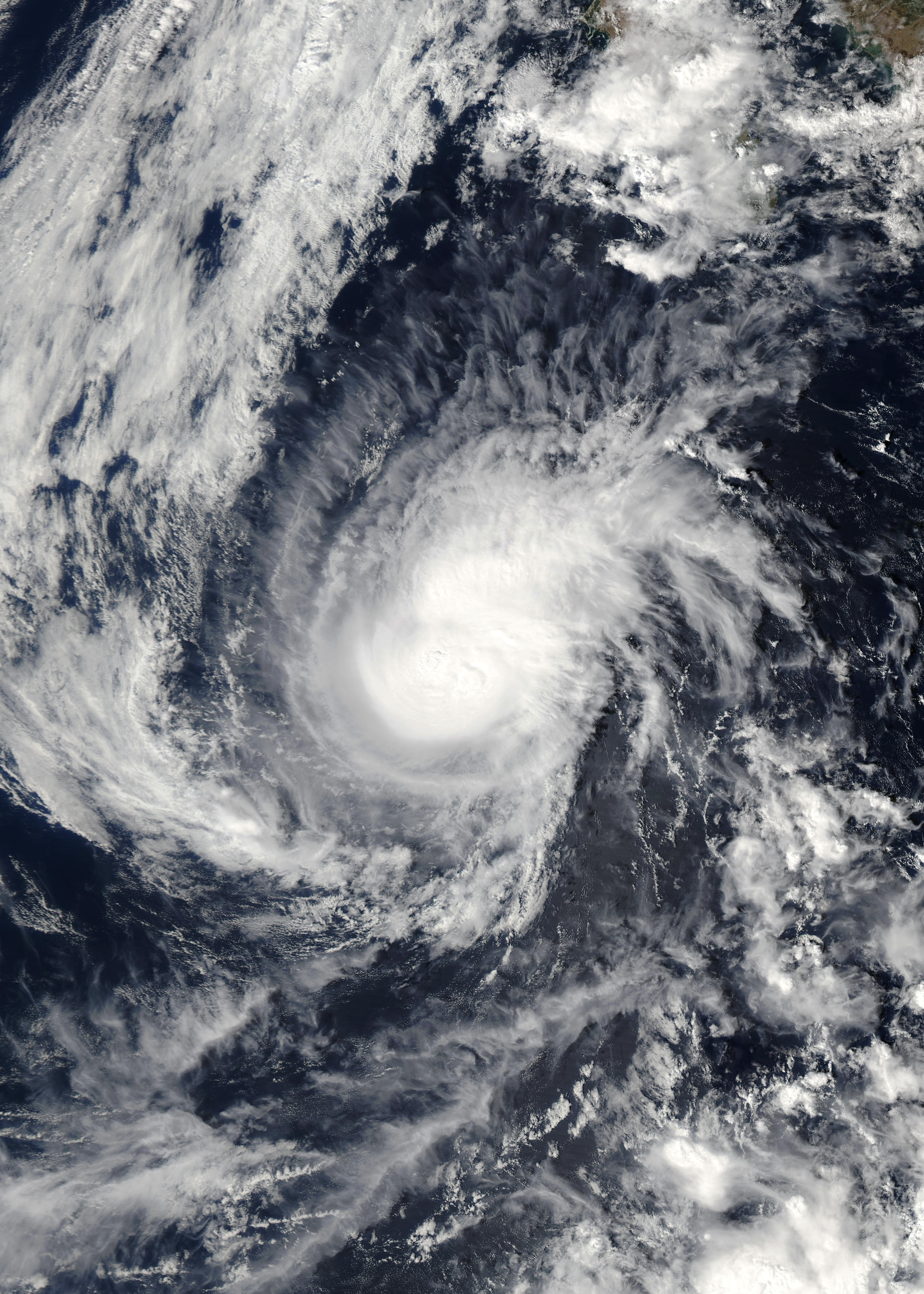
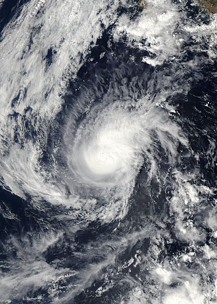
Image: Hurricane Paul 23 oct 2006 2030Z
Description: Hurricane Paul formed on October 21, 2006, in the eastern Pacific near the coast of Mexico. It grew quickly to hurricane strength as it spun off the coast near Baja California for the next several days. The sixteenth named storm of the Pacific storm system, Paul remained offshore and never seriously threatened any major land structures, though residents of southern Baja California were eyeing it warily for signs it might shift and come ashore there. This photo-like image was acquired by the Moderate Resolution Imaging Spectroradiometer (MODIS) on the Aqua satellite on October 23 2006, at 12:30 p.m. local time (20:30 UTC). Paul at the time of this image was a small well-defined spiral swirl which was no longer considered a threat to Baja California. However beyond the tightly wound hurricane, this image shows very wide cloud structures loosely shaped around the storm suggestive that the hurricane was having far reaching effects beyond its immediate reach, with heavy cloud structures extended far offshore as well as over southern Baja. Winds around the center of Hurricane Paul were whipping around at 160 kilometers per hour (100 miles per hour) according to the University of Hawaii’s Tropical Storm Information Center. In 2005, the record-breaking Atlantic hurricane season was the focus of attention, with the number of named storms exhausting the letters of the alphabet. But as of late October 2006, the hurricane activity in the eastern Pacific Ocean was outpacing the Atlantic: 16 named storms (9 of them hurricanes) versus 9 named storms (5 of them hurricanes). On average, the eastern Pacific Ocean experiences more tropical storms and hurricanes than the Atlantic Basin, 16.4 compared to 10.1. Powerful hurricanes in the eastern Pacific rarely make landfall in the western United States. Persistent easterly winds not only tend to steer storms away from the coast, but they also “shove” the ocean’s surface water westward, away from the coast, allowing cool water to well up to replace it. The cool water weakens any storms that do approach the coast.
Title: Hurricane Paul 23 oct 2006 2030Z
Credit: http://earthobservatory.nasa.gov/NaturalHazards/natural_hazards_v2.php3?img_id=13937
Author: NASA image created by Jesse Allen, Earth Observatory, using data obtained courtesy of the MODIS Rapid Response team.
Permission: This file is in the public domain in the United States because it was solely created by NASA. NASA copyright policy states that "NASA material is not protected by copyright unless noted". (See Template:PD-USGov, NASA copyright policy page or JPL Image Use Policy.) Warnings: Use of NASA logos, insignia and emblems is restricted per U.S. law 14 CFR 1221. The NASA website hosts a large number of images from the Soviet/Russian space agency, and other non-American space agencies. These are not necessarily in the public domain. Materials based on Hubble Space Telescope data may be copyrighted if they are not explicitly produced by the STScI.[1] See also Template:PD-Hubble and Template:Cc-Hubble. The SOHO (ESA & NASA) joint project implies that all materials created by its probe are copyrighted and require permission for commercial non-educational use. [2] Images featured on the Astronomy Picture of the Day (APOD) web site may be copyrighted. [3] The National Space Science Data Center (NSSDC) site has been known to host copyrighted content even though its photo gallery FAQ states that all of the images in the photo gallery are in the public domain.
Usage Terms: Public domain
License: Public domain
Attribution Required?: No
Image usage
The following page links to this image:
