
Image: Ileret trackways

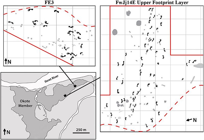
Description: Homo erectus trackways. Schematic maps of excavated footprint surfaces at sites FE3 and FwJj14E. Map of the Ileret area (lower left) shows the locations of sites FE3 and FwJj14E, marked by black stars. Schematic maps of the excavated surfaces at FE3 (top left) and the FwJj14E Upper Footprint Layer (right) show the presence of multiple trackways across each of these surfaces. Print size analyses indicate that the groups of individuals represented at each site consist of predominantly males. Multiple trackways at FwJj14E show parallel directional movement and similar preservation states, suggesting that they could represent a group traveling together. Note that the schematic map of the FwJj14E surface has been rotated relative to North for visualization purposes. Solid red lines mark borders of the current excavations and the same geological layers that preserve footprints are known to extend beyond these borders. Dashed red lines indicate the finite edge of the preserved surface, as areas beyond these lines have been lost due to erosion.
Title: Ileret trackways
Credit: https://doi.org/10.1038/srep28766
Author: Hatala, K. and colleagues
Usage Terms: Creative Commons Attribution-Share Alike 4.0
License: CC BY-SA 4.0
License Link: https://creativecommons.org/licenses/by-sa/4.0
Attribution Required?: Yes
Image usage
The following 2 pages link to this image:
