
Image: Indiana Indian treaties

Size of this PNG preview of this SVG file: 391 × 599 pixels. Other resolution: 156 × 240 pixels.
Original image (SVG file, nominally 2,887 × 4,423 pixels, file size: 313 KB)
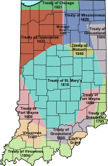
Description: A map of Indiana showing the areas purchased, dates, and the name of the treaties. The land was purchased from Native Americans (American Indians) Treaties by William Henry Harrison, Thomas Posey, Jonathan Jennings, George Rogers Clark. Created by modifiying a map image on the commons
Title: Indiana Indian treaties
Credit: Own work
Author: ArnoldPlaton, vector version of User:Charles_Edward's Indiana Indian treaties.jpg
Usage Terms: Creative Commons Attribution-Share Alike 3.0
License: CC BY-SA 3.0
License Link: http://creativecommons.org/licenses/by-sa/3.0
Attribution Required?: Yes
Image usage
The following 15 pages link to this image:
- Aboriginal title in the United States
- Chief Menominee
- Federal Indian Policy
- Historic regions of the United States
- Historical regions of the United States
- Indian removals in Indiana
- List of treaties between the Potawatomi and the United States
- Miami people
- Treaty of Fort Wayne (1803)
- Treaty of Fort Wayne (1809)
- Treaty of Grouseland
- Treaty of St. Mary's (1818)
- Treaty of Tippecanoe
- Treaty of Vincennes
- Treaty of the Wabash

All content from Kiddle encyclopedia articles (including the article images and facts) can be freely used under Attribution-ShareAlike license, unless stated otherwise.