
Image: Inshore Waters of Great Britain

Size of this PNG preview of this SVG file: 385 × 599 pixels. Other resolution: 154 × 240 pixels.
Original image (SVG file, nominally 675 × 1,050 pixels, file size: 495 KB)
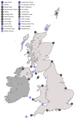
Description: Map showing the locations of areas mentioned in the inshore weather report of the Shipping Forecast. Numbers in grey circles represent area delimiters, letters in blue circles represent other important bodies of water and islands.
Title: Inshore Waters of Great Britain
Credit: British_Isles_United_Kingdom.svg
Author: derivative work: Smurrayinchester (talk) British_Isles_United_Kingdom.svg: Cnbrb
Usage Terms: Public domain
License: Public domain
Attribution Required?: No
Image usage
The following page links to this image:

All content from Kiddle encyclopedia articles (including the article images and facts) can be freely used under Attribution-ShareAlike license, unless stated otherwise.