
Image: Iraqi Civil War map (2014–present)

Size of this preview: 586 × 599 pixels. Other resolutions: 235 × 240 pixels | 3,360 × 3,436 pixels.
Original image (3,360 × 3,436 pixels, file size: 821 KB, MIME type: image/png)
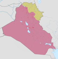
Description: Map of the Second Iraqi War. After updating this map, please also update the date(s) at w:Module:Iraq Syria map date, used to denote the date in articles. Controlled by the Iraqi Government Controlled by ISIS Controlled by Peshmerga (Kurdistan Regional Government) and other Kurdish forces from the Kurdistan Region
Title: Iraqi Civil War map (2014–present)
Credit: Own work w:en:Template:Iraqi insurgency detailed map
Author: Absalao777
Usage Terms: Creative Commons Attribution-Share Alike 3.0
License: CC BY-SA 3.0
License Link: https://creativecommons.org/licenses/by-sa/3.0
Attribution Required?: Yes
Image usage
The following page links to this image:

All content from Kiddle encyclopedia articles (including the article images and facts) can be freely used under Attribution-ShareAlike license, unless stated otherwise.
.png)