
Image: Ireland regions

Size of this PNG preview of this SVG file: 490 × 600 pixels. Other resolution: 196 × 240 pixels.
Original image (SVG file, nominally 2,450 × 3,000 pixels, file size: 3.68 MB)
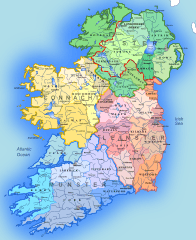
Description: A map showing the 4 provinces of Ireland and the traditional Irish counties. Source: Atlas of William Mackenzie (1846) - map of Ireland and own work.
Title: Ireland regions
Credit: Own work
Author: Andrein
Usage Terms: Creative Commons Attribution-Share Alike 3.0
License: CC BY-SA 3.0
License Link: https://creativecommons.org/licenses/by-sa/3.0
Attribution Required?: Yes
Image usage
The following page links to this image:

All content from Kiddle encyclopedia articles (including the article images and facts) can be freely used under Attribution-ShareAlike license, unless stated otherwise.