
Image: John-Speed-The-Kingdome-of-China-1626-2544

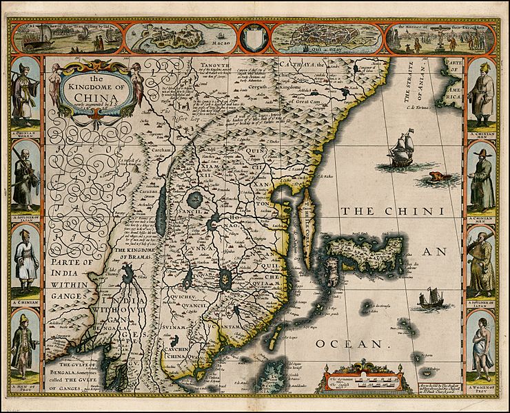
Description: "The Kingdome of China", one of the first English-language maps of China. Note generally correct outline of the Ming China, with many provinces labeled (Cantam/Guangdong, Quancii/Guangxi, Chequiam/Zhejiang, Quicheu/Guizhou, Fuquam/en:Huguang/Huguang, Honao/Henan, Xanton/Shandong, Xiamxii and Sancii (Shanxi and Shaanxi?). "Xuntien alias Quinzay" more or less corresponds to Beijing (the name Shuntian Prefecture was indeed in use). However, north of China proper, John Speed had also placed "Cathaya, the Chief Kingdome of Great Cam", with the capital Cambalu (Khanbaliq - i.e., in fact, the same Beijing). This kind of duplication was common on the maps of the period, as geographers had not apparently yet fully identified Marco Polo's Cathay with the China then known to Europeans, and Cambalu with Beijing.
Title: John-Speed-The-Kingdome-of-China-1626-2544
Credit: An antique map from the Special Collection "China in Maps" of the Hong Kong University of Science and Technology Library, reproduced by the HKUST Library in the book "China in European Maps", Hong Kong, 2003. ISBN 962-86403-9-9.
Author: John Speed
Permission: Author died more than 70 years ago - public domain
Usage Terms: Public domain
License: Public domain
Attribution Required?: No
Image usage
The following 2 pages link to this image:
