
Image: KILLINEY-147 (1424762996)

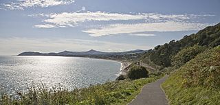
Description: Killiney (Cill Iníon Léinín in Irish, meaning "church of the daughters of Leinin") is a townland in south County Dublin, Ireland on the outskirts of Dublin city within the administrative area of Dun Laoghaire Rathdown County Council. The area is by the coast, south of neighbouring Dalkey, and north to Shankill area in the most southern outskirt of Dublin. It features a village centre and a range of surrounding housing developments. Killiney Hill Park was opened in 1887 in honour of Queen Victoria's 50 years on the throne. The park boasts magnificent views of Dublin Bay, Killiney Bay, Bray Head and the mountain of Great Sugar Loaf (506 m), stretching from the Wicklow Mountains right across to Howth Head. The Park's topography is quite dramatic and its highest point, at the obelisk, is 170 metres above sea level. Other major and minor attractions include Killiney Beach, Killiney Golf Club, a local Martello Tower, and the ruins of Cill Iníon Léinín, the church around which the original village was based. The coastal areas of Killiney are often favourably compared to the Bay of Naples in Italy. This comparison is reflected in the names of surrounding roads, like Vico, Sorrento, Monte Alverno, San Elmo, and Capri. On clear days, the Mourne Mountains of County Down can be seen, although this is less and less frequent due to air pollution. The park was once part of the estate of Killiney Castle, now a hotel.
Title: KILLINEY-147 (1424762996)
Credit: KILLINEY-147.jpg Uploaded by AlbertHerring
Author: William Murphy from Dublin, Ireland
Usage Terms: Creative Commons Attribution-Share Alike 2.0
License: CC BY-SA 2.0
License Link: http://creativecommons.org/licenses/by-sa/2.0
Attribution Required?: Yes
Image usage
The following page links to this image:

.jpg)