
Image: Kapkolonie 1795

Size of this preview: 684 × 599 pixels. Other resolutions: 274 × 240 pixels | 1,000 × 876 pixels.
Original image (1,000 × 876 pixels, file size: 131 KB, MIME type: image/jpeg)
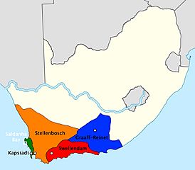
Description: The four regions and administrative centres of Dutch Cape Colony at the eve of British occupation 1795/96: Cape Town (green), Stellenbosch (orange), Swellendam (red), Graaff-Reinet (blue)
Title: Kapkolonie 1795
Credit: based on blank map of Southafrica and informations from De Kaapkolonie omstreeks 1790
Author: User:Roxanna
Usage Terms: Creative Commons Attribution-Share Alike 3.0
License: CC BY-SA 3.0
License Link: http://creativecommons.org/licenses/by-sa/3.0
Attribution Required?: Yes
Image usage
The following page links to this image:

All content from Kiddle encyclopedia articles (including the article images and facts) can be freely used under Attribution-ShareAlike license, unless stated otherwise.