
Image: Kashmir map

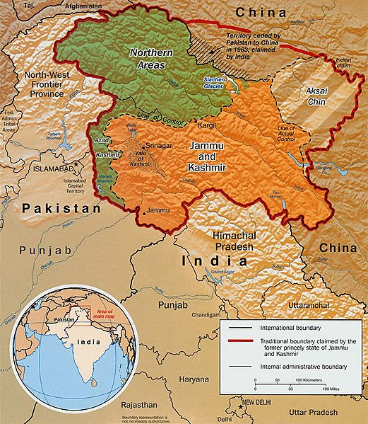
Description: Original text from CIA World Factbook: "The Disputed Territory : Shown in green is Kashmiri region under Pakistani control. The dark-brown region represents Indian-controlled Jammu and Kashmir while the Aksai Chin is under Chinese occupation." Library of Congress, Geography and Map Division, Washington, D.C. 20540-4650 USA. Info from its archive page [1] for this map: Kashmir region. United States. Central Intelligence Agency. CREATED/PUBLISHED [Washington : Central Intelligence Agency, 2003] NOTES "763537AI (R00744) 5-03." Relief shown by shading. Shows boundaries and disputed areas. Includes location map. Scale [ca. 1:510,000]. SUBJECTS Jammu and Kashmir (India)--Maps Jammu and Kashmir (India)--Boundaries--Maps. India--Jammu and Kashmir. MEDIUM 1 map : col. ; 20 x 17 cm. CALL NUMBER G7653.J3 2003 .U51 REPOSITORY Library of Congress Geography and Map Division Washington, D.C. 20540-4650 USA DIGITAL ID g7653j ct001059 http://hdl.loc.gov/loc.gmd/g7653j.ct001059
Title: Kashmir map
Credit: Map is archived here: http://hdl.loc.gov/loc.gmd/g7653j.ct001059 and http://www.lib.utexas.edu/maps/middle_east_and_asia/kashmir_disputed_2003.jpg
Author: Central Intelligence Agency
Permission: This image is in the public domain because it contains materials that originally came from the United States Central Intelligence Agency's World Factbook. Беларуская (тарашкевіца) | বাংলা | Čeština | Deutsch | Zazaki | English | Esperanto | Español | Eesti | Suomi | Français | Hrvatski | Italiano | 日本語 | ქართული | 한국어 | Македонски | മലയാളം | Nederlands | Norsk nynorsk | Polski | Português | Русский | Sicilianu | Slovenščina | Српски / srpski | தமிழ் | Türkçe | Українська | 中文 | 中文(简体) | 中文(繁體) | +/−
Usage Terms: Public domain
License: Public domain
Attribution Required?: No
Image usage
The following 5 pages link to this image:
