
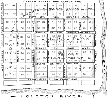
Image: Knoxville-map-1790s-tn1
No higher resolution available.
Knoxville-map-1790s-tn1.png (431 × 398 pixels, file size: 49 KB, MIME type: image/png)
Description: Map of early Knoxville, Tennessee, USA, showing the original 1791 plat of Charles McClung, and the subsequent 1795 expansion to the north and west. The "Holston" is now the Tennessee River.
Title: Knoxville-map-1790s-tn1
Credit: Samuel G. Heiskell, Andrew Jackson and Early Tennessee History (Nashville: Ambrose Printing Company, 1918), p. 60. Downloaded from Google Books, Full View.
Author: Samuel G. Heiskell
Usage Terms: Public domain
License: Public domain
Attribution Required?: No
Image usage
The following page links to this image:

All content from Kiddle encyclopedia articles (including the article images and facts) can be freely used under Attribution-ShareAlike license, unless stated otherwise.