
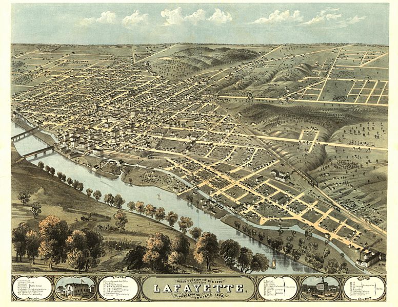
Image: LafayetteIN1868

Description: This panoramic map from LC Panoramic maps (2nd ed.), page 2, illustrates a bird's-eye view of Lafayette, Indiana in 1868. Drawn 1868 by A. Ruger and published in Chicago by Chicago Lith. Co., the perspective map is indexed for points of interest. NOTES: Perspective map not drawn to scale. Includes ill. and index to points of interest. Medium: col. map 56 x 70 cm. Call Number: G4094.L2A3 1868 .R8 Rug 43 .G6. Reference: LC Panoramic maps (2nd ed.), 197 Repository: Library of Congress Geography and Map Division Washington, D.C. 20540-4650 USA. Digital ID: g4094l pm001970
Title: LafayetteIN1868
Credit: Library of Congress Geography and Map Division, Washington, D.C. 20540-4650
Author: A. Ruger
Permission: Public Domain
Usage Terms: Public domain in the United States
License: PD-US
License Link: //en.wikipedia.org/wiki/File:LafayetteIN1868.JPG
Image usage
The following page links to this image:
