
Image: Lake Erie Islands Map

Size of this preview: 800 × 561 pixels. Other resolutions: 320 × 225 pixels | 1,160 × 814 pixels.
Original image (1,160 × 814 pixels, file size: 47 KB, MIME type: image/png)
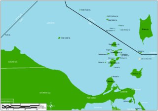
Description: Map showing a majority of the Lake Erie islands that lie between Toledo and Cleveland. Other information For geographic reference only. Not to be used for navigation purposes.
Title: Lake Erie Islands Map
Credit: Drawn in ArcMap and Microsoft Paint
Author: Frank12
Usage Terms: Creative Commons Attribution-Share Alike 3.0
License: CC BY-SA 3.0
License Link: https://creativecommons.org/licenses/by-sa/3.0
Attribution Required?: Yes
Image usage
The following 4 pages link to this image:

All content from Kiddle encyclopedia articles (including the article images and facts) can be freely used under Attribution-ShareAlike license, unless stated otherwise.