
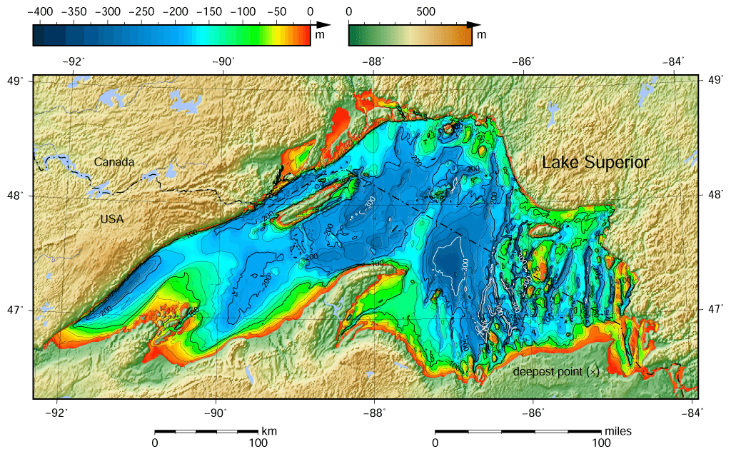
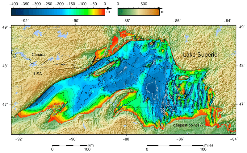
Image: Lake Superior bathymetry map
Description: Lake Superior bathymetric shaded relief map contoured with interval 25 m (100 m with thicker lines). The deepest point, roughly off its southeastern shore, is marked with "×". For land, the vertical datum is sea level; for bathymetry, low water datum of the lake. According to NGDC information, Lake Superior data this map is based on are incomplete. The map was created using the Generic Mapping Tools, GMT, version 5.1.1.
Title: Lake Superior bathymetry map
Credit: Own work using: the following Public Domain datasets (grids): Great Lakes Bathymetry from National Geophysical Data Center http://www.ngdc.noaa.gov/mgg/greatlakes/greatlakes.html. Credits: National Geophysical Data Center, 1999. Bathymetry of Lake Superior. National Geophysical Data Center, NOAA. [access date: 2015-03-23]. (the general reference to NGDC because this lake was never published, compilation of Great Lakes Bathymetry at NGDC has been suspended). National Geophysical Data Center, 1999. Bathymetry of Lake Huron. National Geophysical Data Center, NOAA. doi:10.7289/V5G15XS5 [access date: 2015-03-23]. (only small portion of this map) GLOBE http://www.ngdc.noaa.gov/mgg/topo/gltiles.html - land part of this map. Credits: National Geophysical Data Center, 1999. Global Land One-kilometer Base Elevation (GLOBE) v.1. Hastings, D. and P.K. Dunbar. National Geophysical Data Center, NOAA. doi:10.7289/V52R3PMS [access date: 2015-03-16]. The coordinates of deepest point are taken from the NOAA Great Lakes Environmental Research Laboratory webpage (www.glerl.noaa.gov/, kml file Google Earth Great Lakes Tour). The contours are generated by the GMT program, not downloaded from the NGDC website because they are not available for Lake Superior. The color palette of the depth scale was made to be more or less similar to the color palettes used on the NGDC maps of other Great Lakes. Created with Generic Mapping Tools (GMT)
Author: Darekk2 using the Great Lakes Bathymetry and GLOBE tiles
Usage Terms: Creative Commons Attribution-Share Alike 4.0
License: CC BY-SA 4.0
License Link: http://creativecommons.org/licenses/by-sa/4.0
Attribution Required?: Yes
Image usage
There are no pages that link to this image.
