
Image: Lake Tiberias (Sea of Galilee), Northern Israel

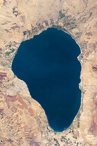
Description: Israel’s largest freshwater lake, Lake Tiberias, is also known as the Sea of Tiberias, Lake of Gennesaret, Lake Kinneret, and the Sea of Galilee. The lake measures just more than 21 kilometres north-south, and it is only 43 meters deep. The lake is fed partly by underground springs related to the Jordan sector of the Great Rift Valley, but most of its water comes from the Jordan River, which enters from the north. The river’s winding course can be seen draining the south end of the lake at image bottom. Angular green and brown field patterns clothe most hillsides in this arid landscape. Bright roof tops are the hallmark of several villages in the area. The largest grouping of bright roofs and city blocks indicates the location of Tiberias (named for the Roman Emperor Tiberius), visible at image left on the south-western shore of the lake. ISS Crew Earth Observations: ISS020-E-31066 Identification Mission ISS020 (Expedition 20) Roll E Frame 31066 Country or Geographic Name ISRAEL Features SEA OF GALILEE, TIBERIAS, AGR. Center Point Latitude 32.8° N Center Point Longitude 35.6° E Camera Camera Tilt 27° Camera Focal Length 400 mm Camera Nikon D2Xs Film 4288 x 2848 pixel CMOS sensor, RGBG imager color filter. Quality Percentage of Cloud Cover 0-10% Nadir What is Nadir? Date 2009-08-15 Time 10:21:01 Nadir Point Latitude 31.3° N Nadir Point Longitude 35.0° E Nadir to Photo Center Direction North Sun Azimuth 208° Spacecraft Altitude 189 nautical miles (350 km) Sun Elevation Angle 71° Orbit Number 1528
Title: Lake Tiberias (Sea of Galilee), Northern Israel
Credit: NASA Earth Observatory
Author: This image was taken by the NASA Expedition 20 crew.
Usage Terms: Public domain
License: Public domain
Attribution Required?: No
Image usage
The following page links to this image:

,_Northern_Israel.jpg)