
Image: Lakebalkhashbasinmap

Size of this preview: 800 × 546 pixels. Other resolutions: 320 × 218 pixels | 1,466 × 1,000 pixels.
Original image (1,466 × 1,000 pixels, file size: 1.52 MB, MIME type: image/png)
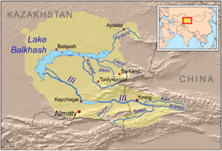
Description: This is a map of the Lake Balkhash drainage basin, including the Ili River and its tributaries.
Title: Lakebalkhashbasinmap
Credit: Own work using Digital Chart of the World and GTOPO data, labels based on GEOnet. UNEP and Decrease of river runoff in the Lake Balkhash basin in Central Asia by Kader Kezer and Hiroshi Matsuyama used as references.
Author: Kmusser
Usage Terms: Creative Commons Attribution-Share Alike 3.0
License: CC BY-SA 3.0
License Link: http://creativecommons.org/licenses/by-sa/3.0
Attribution Required?: Yes
Image usage
The following 3 pages link to this image:

All content from Kiddle encyclopedia articles (including the article images and facts) can be freely used under Attribution-ShareAlike license, unless stated otherwise.