
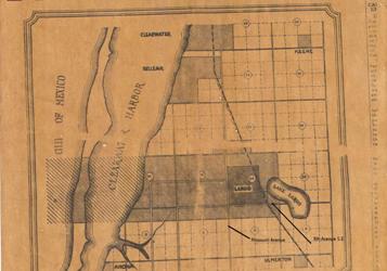
Image: Largo, Florida Map Mar 6,1925
No higher resolution available.
Largo,_Florida_Map_Mar_6,1925.jpg (357 × 250 pixels, file size: 17 KB, MIME type: image/jpeg)
Description: Map showing the old and new corporate bounds of the City of Largo, Florida. Shows the new city boundaries around old town boundaries in effect from 1925 to 1933.
Title: Largo, Florida Map Mar 6,1925
Credit: From The Largo Sentinel issue of March 6, 1925. This image is from a historical society archive. Scanned, cropped, and reduced to below 300 x 300 by Deepfriedokra.
Author: Unknown authorUnknown author
Usage Terms: Public domain
License: Public domain
Attribution Required?: No
Image usage
The following page links to this image:

All content from Kiddle encyclopedia articles (including the article images and facts) can be freely used under Attribution-ShareAlike license, unless stated otherwise.