
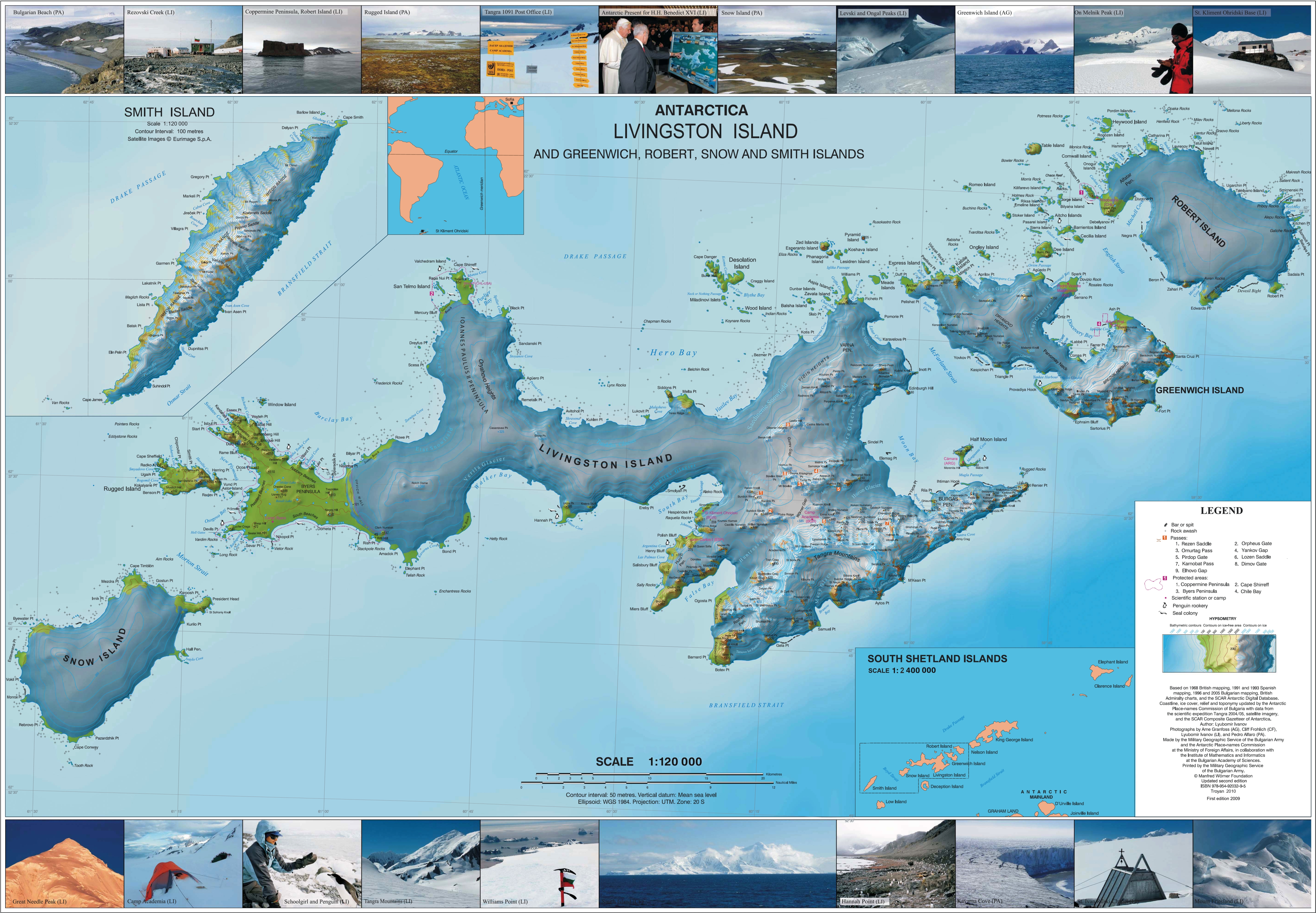
Image: Livingston-Island-Map-2010
Description: L.L. Ivanov. Antarctica: Livingston Island and Greenwich, Robert, Snow and Smith Islands. Scale 1:120000 topographic map. Troyan: Manfred Wörner Foundation, 2010. ISBN 978-954-92032-9-5 (First edition 2009. ISBN 978-954-92032-6-4)
Title: Livingston-Island-Map-2010
Credit: Own work
Author: Apcbg
Permission: This work is free and may be used by anyone for any purpose. If you wish to use this content, you do not need to request permission as long as you follow any licensing requirements mentioned on this page. Wikimedia Foundation has received an e-mail confirming that the copyright holder has approved publication under the terms mentioned on this page. This correspondence has been reviewed by an OTRS member and stored in our permission archive. The correspondence is available to trusted volunteers as ticket #2015062910008131. If you have questions about the archived correspondence, please use the OTRS noticeboard. Ticket link: https://ticket.wikimedia.org/otrs/index.pl?Action=AgentTicketZoom&TicketNumber=2015062910008131
Usage Terms: Creative Commons Attribution-Share Alike 4.0
License: CC BY-SA 4.0
License Link: https://creativecommons.org/licenses/by-sa/4.0
Attribution Required?: Yes
Image usage
The following 34 pages link to this image:
- Aitcho Islands (South Shetland Islands)
- Atherton Islands
- Barrientos Island
- Bilyana Island
- Bizone Rock
- Cacho Island
- Cave Island
- Cecilia Island
- Dee Island
- Dunbar Islands
- Emeline Island
- Esperanto Island
- Gergini Reef
- González Island
- Kabile Island
- Korsis Island
- Lesidren Island
- Liberty Rocks
- Lientur Rocks
- Meade Islands
- Mellona Rocks
- Ogygia Island
- Ongley Island
- Onogur Islands
- Phanagoria Island
- Pyramid Island, South Shetland Islands
- Riksa Islands
- Robert Island
- Snow Island (South Shetland Islands)
- South Shetland Islands
- Square End Island
- Tirizis Island
- Wood Island (Livingston Island)
- Zed Islands
