
Image: Location map Indianapolis central

Size of this preview: 800 × 547 pixels. Other resolutions: 320 × 219 pixels | 1,206 × 824 pixels.
Original image (1,206 × 824 pixels, file size: 733 KB, MIME type: image/png)
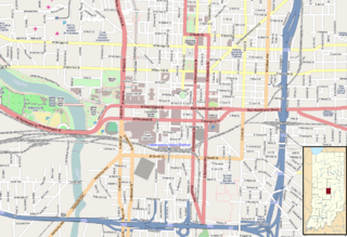
Description: Map of Indianapolis Geographic limits of the map: N: 39.779° S: 39.752° W: -86.185° E: -86.134°
Title: Location map Indianapolis central
Credit: Maps for Free (OSM) . Insert is based on File:USA Indiana location map.svg
Author: Dr. Blofeld. Insert by Alexrk2
Usage Terms: Creative Commons Attribution-Share Alike 2.0
License: CC BY-SA 2.0
License Link: https://creativecommons.org/licenses/by-sa/2.0
Attribution Required?: Yes
Image usage
The following 23 pages link to this image:
- Athenæum (Das Deutsche Haus)
- Birch Bayh Federal Building and United States Courthouse
- Cole Motor Car Company
- Cottage Home Historic District
- H. P. Wasson and Company
- Indiana State Library and Historical Bureau
- Indiana Statehouse
- Indiana Theatre (Indianapolis)
- Indianapolis Masonic Temple
- Indianapolis Union Station
- Indianapolis White Castle
- Kahn Tailoring Company Building
- Lockefield Gardens
- Lockerbie Square Historic District
- Military Park (Indianapolis)
- Mt. Pisgah Lutheran Church
- Omni Severin Hotel
- Ransom Place Historic District
- Roberts Park Methodist Episcopal Church
- Scottish Rite Cathedral (Indianapolis)
- Slippery Noodle Inn
- Soldiers' and Sailors' Monument (Indianapolis)
- The Columbia Club

All content from Kiddle encyclopedia articles (including the article images and facts) can be freely used under Attribution-ShareAlike license, unless stated otherwise.