
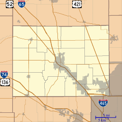
Image: Location map of Boone County, Indiana

Size of this PNG preview of this SVG file: 600 × 600 pixels. Other resolution: 240 × 240 pixels.
Original image (SVG file, nominally 768 × 768 pixels, file size: 271 KB)
Description: This is a map of Boone County, Indiana, USA which includes incorporated settlements, township borders, and major highways.
Title: Location map of Boone County, Indiana
Credit: My own work, using custom-written MapScript applications with United States Census Bureau data
Author: Omnedon
Usage Terms: Public domain
License: Public domain
Attribution Required?: No
Image usage
The following 21 pages link to this image:
- Big Springs, Indiana
- Eagle Village, Indiana
- Elizaville, Indiana
- Fayette, Indiana
- Gadsden, Indiana
- Hazelrigg, Indiana
- Herr, Indiana
- Max, Indiana
- Mechanicsburg, Boone County, Indiana
- Milledgeville, Indiana
- New Brunswick, Indiana
- Northfield, Indiana
- Pike, Indiana
- Pryor Brock Farmstead
- Rosston, Indiana
- Royalton, Indiana
- Shepherd, Indiana
- Stringtown, Boone County, Indiana
- Terhune, Indiana
- Ward, Indiana
- Waugh, Indiana

All content from Kiddle encyclopedia articles (including the article images and facts) can be freely used under Attribution-ShareAlike license, unless stated otherwise.