
Image: LocationofRichlandMill
No higher resolution available.
LocationofRichlandMill.gif (300 × 287 pixels, file size: 20 KB, MIME type: image/gif)
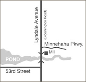
Description: Map showing location of the Richland Mill on Minnehaha Creek and Lyndale Avenue (Bloomington Road) in the Township of Richfield (Present day in the boundaries of Minneapolis, Minnesota). Map illustration by Joe Hoover, 2007, for book: "Richfield: Minnesota's Oldest Suburb" published by the Richfield Historical Society. Reproduced with permission of the artist and released to public domain courtesy of Joe Hoover.
Title: LocationofRichlandMill
Credit: Transferred from en.wikipedia to Commons by Innotata using CommonsHelper.
Author: Myotus at English Wikipedia
Usage Terms: Public domain
License: Public domain
Attribution Required?: No
Image usage
The following page links to this image:

All content from Kiddle encyclopedia articles (including the article images and facts) can be freely used under Attribution-ShareAlike license, unless stated otherwise.