
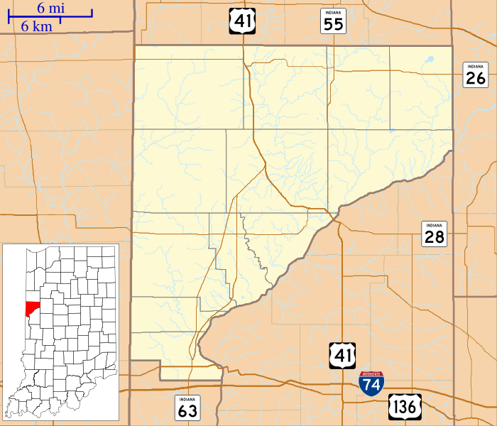
Image: Locator map of Warren County, Indiana

Size of this PNG preview of this SVG file: 700 × 600 pixels. Other resolution: 280 × 240 pixels.
Original image (SVG file, nominally 896 × 768 pixels, file size: 590 KB)
Description: This is a map of Warren County, Indiana, USA which includes township borders.
Title: Locator map of Warren County, Indiana
Credit: My own work, using freely-available shape data from the United States Census Bureau with a custom-written MapScript application
Author: Omnedon
Usage Terms: Public domain
License: Public domain
Attribution Required?: No
Image usage
The following 39 pages link to this image:
- Baltimore, Indiana
- Banning Corner, Indiana
- Black Rock, Indiana
- Brisco, Indiana
- Carbondale, Indiana
- Chatterton, Indiana
- Chesapeake, Indiana
- Dresser, Indiana
- Five Points, Warren County, Indiana
- Foster, Indiana
- Glen Cliff, Indiana
- Green Hill, Indiana
- Hedrick, Indiana
- Hooker Corner, Indiana
- Independence, Indiana
- Johnsonville, Indiana
- Judyville, Indiana
- Kickapoo, Indiana
- Kramer, Indiana
- Locust Grove, Warren County, Indiana
- Marshfield, Indiana
- Mudlavia Springs, Indiana
- Old Town, Indiana
- Pence, Indiana
- Pine Village, Indiana
- Point Pleasant, Indiana
- Rainsville, Indiana
- Romine Corner, Indiana
- Sloan, Indiana
- State Line City, Indiana
- Stewart, Indiana
- Sycamore Corner, Indiana
- Tab, Indiana
- Walnut Grove, Warren County, Indiana
- Warren County Courthouse (Indiana)
- Warrenton, Indiana
- West Lebanon, Indiana
- Williamsport, Indiana
- Winthrop, Indiana

All content from Kiddle encyclopedia articles (including the article images and facts) can be freely used under Attribution-ShareAlike license, unless stated otherwise.