
Image: London Stone, Yantlet 338

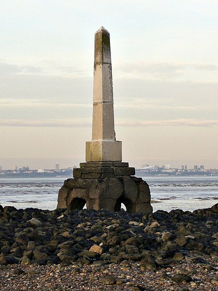
Description: The London Stone at grid reference TQ 860 786 at the mouth of Yantlet Creek on the Isle of Grain. Southend-on-Sea can be seen in the background on the other side of the Thames. One of a number of London Stones, this one stands beside the Thames at the mouth of Yantlet Creek. It marked the downstream limit of the control of the river by the City of London Corporation. The corresponding marker on the other side of the river is The Crowstone near Southend-on-Sea, which can be seen in the background of this picture. The line between these stones is the "Yantlet Line" which is still used as a boundary for various things: Google search for Yantlet Line. The corresponding marker above London is London Stone, Staines at 31 km as the crow flies upstream from London Bridge. But this stone at Yantlet is 54 km downstream. Direct access to the stone is difficult because Grain Marsh is an MoD firing range. To take this photo, I approached from the British Pilot in Allhallows and paddled through Yantlet Creek. Here are my feet on the way back. More images.
Title: London Stone, Yantlet 338
Credit: Own work
Author: Roger W Haworth
Usage Terms: Creative Commons Attribution 2.5
License: CC BY 2.5
License Link: https://creativecommons.org/licenses/by/2.5
Attribution Required?: Yes
Image usage
The following page links to this image:
