
Image: Louisville-Jefferson County-Elizabethtown-Bardstown CSA
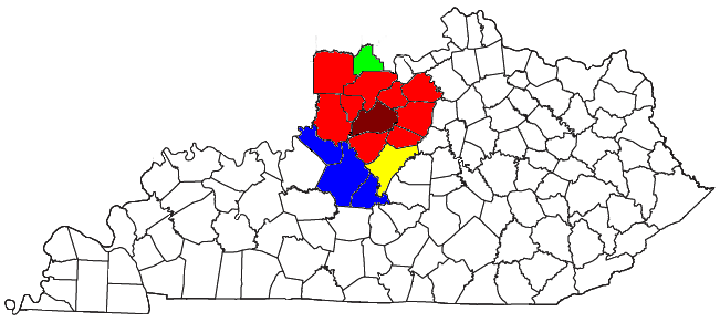
Description: Locator map of the Louisville-Jefferson County-Elizabethtown-Bardstown Combined Statistical Area in the northwestern part of the U.S. state of Kentucky and southern part of the U.S. State of Indiana. The four components of the CSA are colored separately: Louisville-Jefferson County, Kentucky: dark red Surrounding counties in Louisville-Jefferson County, Kentucky-Indiana Metropolitan Statistical Area: red Elizabethtown-Fort Knox, Kentucky Metropolitan Statistical Area: blue Bardstown, Kentucky Micropolitan Statistical Area: yellow Scottsburg, Indiana Micropolitan Statistical Area: green
Title: Louisville-Jefferson County-Elizabethtown-Bardstown CSA
Credit: Modified from this United States Census Bureau file, based on this Census definitions list.
Author: Yassie (talk)
Permission: US Government work is public domain, and my work is Public domainPublic domainfalsefalse I, the copyright holder of this work, release this work into the public domain. This applies worldwide. In some countries this may not be legally possible; if so: I grant anyone the right to use this work for any purpose, without any conditions, unless such conditions are required by law.
Usage Terms: Public domain
License: Public domain
Attribution Required?: No
Image usage
The following page links to this image:
