
Image: Luzon Strait n7184

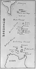
Description: Old map of the Luzon Strait (not labeled), including the Bashi Channel, between Orchid Island (Botel Tobago on the map) of Taiwan and the Batan Islands of the Philippines. Names may be out of date. Japanese caption: "Islands between Taiwan and Luzon".
Title: Luzon Strait n7184
Credit: From digital archive of the University of Tokyo. [1] Cropped by a-giâu.
Author: anthropologist Torii Ryūzō (1870-1953)
Permission: This photographic image was published before December 31st 1956, or photographed before 1946, under the jurisdiction of the Government of Japan. Thus this photographic image is considered to be public domain according to article 23 of old copyright law of Japan (English translation) and article 2 of supplemental provision of copyright law of Japan. To uploader: Please provide an image source. Deutsch | English | français | italiano | 日本語 | 한국어 | македонски | português | русский | 中文 | 中文(简体) | 中文(繁體) | +/−
Usage Terms: Public domain
License: Public domain
Attribution Required?: No
Image usage
The following page links to this image:
