
Image: ManchesterMaps

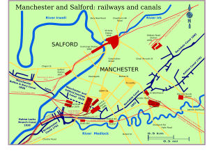
Description: From 1761 to 1802, Manchester was transformed by canals bringing in coal to build a city. The Rochdale Canal built in 1800, passes between the Ashton Canal in Piccadilly and the Bridgewater Canal at Castlefield.The city was riddled with branch canals. Then again between 1830 and 1845 railways were invented, and penetrated the city- while the canal companies refined their networks, the city reinvented itself. Trans-shipment wharfs and warehouses linked the two systems. By 1950 all had declined, the city actively forget. With the 1990s, the city again reinvents itself and some of the heritage has been opened up. This map attempts to continue the work of Owen Ashmore, The industrial archaeology of NW England, 1982, MUP, taking his B&W map (p108), other textual sources and using http://www.openstreetmap.org/index.html?mlat=53.487216&mlon=-2.228851&zoom=11&layers=B000FTF as base layer. The svg file was created using Inkscape supported by Ubuntu Linux.
Title: ManchesterMaps
Credit: I, the copyright holder of this work, hereby publish it under the following license:
Author: Clem Rutter, Rochester, Kent.
Permission: Own work, attribution required (Multi-license with GFDL and Creative Commons CC-BY 3.0)
Usage Terms: Creative Commons Attribution 3.0
License: CC BY 3.0
License Link: https://creativecommons.org/licenses/by/3.0
Attribution Required?: Yes
Image usage
The following page links to this image:
