
Image: Manchester parish map

Size of this PNG preview of this SVG file: 673 × 599 pixels. Other resolution: 270 × 240 pixels.
Original image (SVG file, nominally 913 × 813 pixels, file size: 246 KB)
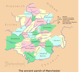
Description: A vectorised & colorised version of the map at Farrer & Brownbill (1911), The Victoria history of the county of Lancaster. - Lancashire, Vol 4, p 175.
Title: Manchester parish map
Credit: Own work, after Farrer & Brownbill
Author: Mr Stephen
Permission: CC-BY-SA-2.5
Usage Terms: Creative Commons Attribution-Share Alike 2.5
License: CC BY-SA 2.5
License Link: http://creativecommons.org/licenses/by-sa/2.5
Attribution Required?: Yes
Image usage
The following 2 pages link to this image:

All content from Kiddle encyclopedia articles (including the article images and facts) can be freely used under Attribution-ShareAlike license, unless stated otherwise.