
Image: Map Anatolia ancient regions-en

Size of this PNG preview of this SVG file: 800 × 518 pixels. Other resolution: 320 × 207 pixels.
Original image (SVG file, nominally 921 × 596 pixels, file size: 278 KB)
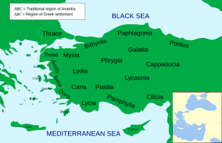
Description: Regional map of Asia Minor in the 2nd Century BC
Author: Asia_Minor_Political_500BC.svg: *Mysia.svg: Emok
derivative work:
Mysia_map_ancient_community.jpg: User:Roke derivative work: MinisterForBadTimes (talk) derivative work: MinisterForBadTimes (talk)
Usage Terms: Creative Commons Attribution-Share Alike 3.0
License: CC-BY-SA-3.0
License Link: http://creativecommons.org/licenses/by-sa/3.0/
Attribution Required?: Yes
Image usage
The following page links to this image:

All content from Kiddle encyclopedia articles (including the article images and facts) can be freely used under Attribution-ShareAlike license, unless stated otherwise.