
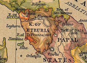
Image: Map Kingdom of Etruria
No higher resolution available.
Map_Kingdom_of_Etruria.jpg (299 × 218 pixels, file size: 32 KB, MIME type: image/jpeg)
Description: Etruria in 1806
Title: Map Kingdom of Etruria
Credit: This image is a copy or a derivative work of germany_italy_1806.jpg, from the map collection of the Perry-Castañeda Library (PCL) of the University of Texas at Austin. This tag does not indicate the copyright status of the attached work. A normal copyright tag is still required. See Commons:Licensing for more information. From The Historical Atlas by William R. Shepherd, 1926.
Author: William Robert Shepherd
Permission: PCL states map is PD
Usage Terms: Public domain
License: Public domain
Attribution Required?: No
Image usage
The following page links to this image:

All content from Kiddle encyclopedia articles (including the article images and facts) can be freely used under Attribution-ShareAlike license, unless stated otherwise.