
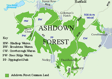
Image: Map of Ashdown Forest, East Sussex
No higher resolution available.
Map_of_Ashdown_Forest,_East_Sussex.jpg (380 × 268 pixels, file size: 112 KB, MIME type: image/jpeg)
Description: A map of Ashdown Forest, East Sussex, showing its common land and highlighting the largest of the enclosures confirmed in the 1693 decree that divided up the forest. The major enclosures are at Pippingford Park and Old Lodge (PP) ; Crowborough Warren (CW); Hindleap Warren (HW); 500 Acre Wood; Prestridge Warren (PW); and Broadstone Warren (BW).
Title: Map of Ashdown Forest, East Sussex
Credit: Own work
Author: Dartford Warbler
Usage Terms: Creative Commons Attribution-Share Alike 3.0
License: CC BY-SA 3.0
License Link: http://creativecommons.org/licenses/by-sa/3.0
Attribution Required?: Yes
Image usage
The following page links to this image:

All content from Kiddle encyclopedia articles (including the article images and facts) can be freely used under Attribution-ShareAlike license, unless stated otherwise.