
Image: Map of Lydia ancient times
No higher resolution available.
Map_of_Lydia_ancient_times.jpg (400 × 277 pixels, file size: 44 KB, MIME type: image/jpeg)
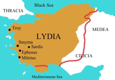
Description: Edge of the brown area is the border of Lydia at the middle of the 6th century BC. The red line is the different border shown in the second map.
Title: Map of Lydia ancient times
Credit: Info from these maps: Map 1 (brown): "middle of the 6th century at the time of King Croesus" http://i-cias.com/e.o/lydia.htm Map 2 (red line): "7th C. BCE roughly from 690 to 546 BCE" http://www.ancientanatolia.com/map07.htm
Author: User:Roke (Own work)
Usage Terms: Creative Commons Attribution-Share Alike 3.0
License: CC-BY-SA-3.0
License Link: http://creativecommons.org/licenses/by-sa/3.0/
Attribution Required?: Yes
Image usage

All content from Kiddle encyclopedia articles (including the article images and facts) can be freely used under Attribution-ShareAlike license, unless stated otherwise.