
Image: Map of New York Economic Regions

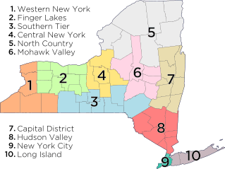
Description: Regions of the US state of New York as defined by the New York Department of Economic Development: Western New York – counties: Niagara, Erie, Chautauqua, Cattaraugus, Allegany; Finger Lakes – counties: Orleans, Genesee, Wyoming, Monroe, Livingston, Wayne, Ontario, Yates, Seneca; Southern Tier – counties: Steuben, Schuyler, Chemung, Tompkins, Tioga, Chenango, Broome, Delaware; Central New York – counties: Cortland, Cayuga, Onondaga, Oswego, Madison; North Country – counties: St. Lawrence, Lewis, Jefferson, Hamilton, Essex, Clinton, Franklin; Mohawk Valley – counties: Oneida, Herkimer, Fulton, Montgomery, Otsego, Schoharie; Capital District – counties: Albany, Columbia, Greene, Warren, Washington, Saratoga, Schenectady, Rensselaer; Hudson Valley – counties: Sullivan, Ulster, Dutchess, Orange, Putnam, Rockland, Westchester; New York City – counties (boroughs): New York (Manhattan), Bronx (The Bronx), Queens (Queens), Kings (Brooklyn), Richmond (Staten Island); Long Island – counties: Nassau, Suffolk.
Title: Map of New York Economic Regions
Credit: Own work
Author: Vmanjr
Usage Terms: Creative Commons Attribution-Share Alike 3.0
License: CC BY-SA 3.0
License Link: http://creativecommons.org/licenses/by-sa/3.0
Attribution Required?: Yes
Image usage
The following 5 pages link to this image:
