
Image: Map of Springfield Armory campus

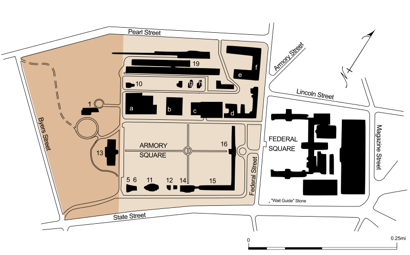
Description: Map of the Springfield Armory, with National Historic Site managed by National Park Service Springfield Technical Community College . Buildings with numbers indicate historic buildings with original numbering, including- National Historic Site 1. Commanding Officers Quarters (1846) 10. Master Armorer's House (1833) 13. Main Arsenal, museum and visitor center (1847) Armory Square and Springfield Technical Community College 5/6. Junior Officers' Quarters (1870) 11. West Arsenal (1808); now Western Massachusetts Police Academy 14. Middle Arsenal (1830); now Armory Square Childcare and College Graphic Communications 15. East Arsenal (1824); now Garvey Hall South 16. Administration (1819), North and South Shops (1824); now Garvey Hall 19. Caserne (1863), now Ira H. Rubenzahl Student Learning Commons Letters indicate other buildings used by Springfield Technical Community College- a. Scibelli Hall b. Deliso Hall c. Putnam Hall d. Mail/Receiving e. Automotive Technology f. Health Sciences Building g. Facilities Department h. Campus Police The "'Wait Guide' Stone" referred to here is the westernmost terminal of the 1767 Milestones.
Title: Map of Springfield Armory campus
Credit: Own work, derived from maps by National Park Service
Author: User:Simtropolitan
Permission: Public domainPublic domainfalsefalse I, the copyright holder of this work, release this work into the public domain. This applies worldwide. In some countries this may not be legally possible; if so: I grant anyone the right to use this work for any purpose, without any conditions, unless such conditions are required by law.
Usage Terms: Public domain
License: Public domain
Attribution Required?: No
Image usage
The following page links to this image:
