
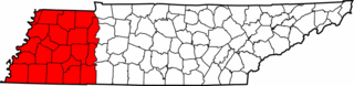
Image: Map of West Tennessee counties

Size of this preview: 800 × 196 pixels. Other resolutions: 320 × 78 pixels | 1,000 × 245 pixels.
Original image (1,000 × 245 pixels, file size: 34 KB, MIME type: image/png)
Description: Map showing the counties of West Tennessee, United States.
Title: Map of West Tennessee counties
Credit: Own work; File:Tennessee county locator map - blank.png
Author: User:Huntster
Usage Terms: Creative Commons Attribution-Share Alike 3.0
License: CC-BY-SA-3.0
License Link: http://creativecommons.org/licenses/by-sa/3.0/
Attribution Required?: Yes
Image usage
The following 6 pages link to this image:

All content from Kiddle encyclopedia articles (including the article images and facts) can be freely used under Attribution-ShareAlike license, unless stated otherwise.