
Image: Map of Whangarata railway station in 1920s
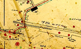
Description: Auckland Libraries Heritage Collections CP-20 - A manuscript map of part of the Tuakau, Whangarata and Pokeno power line network, showing unnamed streets and the position of the power lines for this area. Includes the names of property owners.
Title: Map of Whangarata railway station in 1920s
Credit: http://www.aucklandcity.govt.nz/dbtw-wpd/exec/dbtwpub.dll?BU=http%3A%2F%2Fwww.aucklandcity.govt.nz%2Fdbtw-wpd%2FHeritageImages%2Findex.htm&AC=QBE_QUERY&TN=heritageimages&QF0=ID&NP=2&MR=5&RF=HIORecordSearch&QI0=%3D%22CP-20%22
Author: Franklin Electric Power Board
Usage Terms: Creative Commons Attribution-Share Alike 4.0
License: CC BY-SA 4.0
License Link: https://creativecommons.org/licenses/by-sa/4.0
Attribution Required?: Yes
Image usage
The following page links to this image:
