
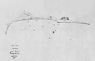
Image: Map of Yam Bay and Niihau, Captain George Dixon's Journal, 1788

Size of this preview: 800 × 517 pixels. Other resolutions: 320 × 207 pixels | 941 × 608 pixels.
Original image (941 × 608 pixels, file size: 51 KB, MIME type: image/jpeg)
Description: A map of Yam Bay and the island of Niihau in Captain George Dixon's journal in 1788. For many years Niihau was called Yam Island by Western sailors because of the high quality of yams grown there.
Title: Map of Yam Bay and Niihau, Captain George Dixon's Journal, 1788
Credit: Edward Joesting (1988) Kauai: The Separate Kingdom, University of Hawaii Press, p. Page 64 ISBN: 9780824811624. Fitzpatrick, Gary L. (1986). "The Early Mapping of Hawaii". Palapalaʻāaina I: 33. Honolulu: Editions Ltd.
Author: Hawaiian Historical Society
Usage Terms: Public domain
License: Public domain
Attribution Required?: No
Image usage
The following page links to this image:

All content from Kiddle encyclopedia articles (including the article images and facts) can be freely used under Attribution-ShareAlike license, unless stated otherwise.