
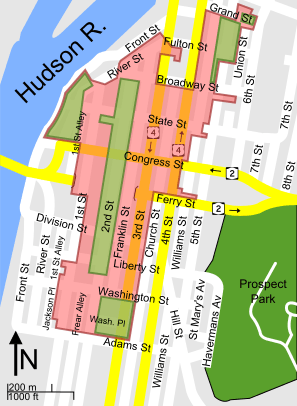
Image: Map of central Troy historic district 2

Size of this PNG preview of this SVG file: 297 × 406 pixels. Other resolution: 175 × 240 pixels.
Original image (SVG file, nominally 297 × 406 pixels, file size: 310 KB)
Description: Map of Central Troy Historic District, located in Troy, New York, United States
Title: Map of central Troy historic district 2
Credit: SVG version of File:Central Troy Historic District map.png. Red boundaries based on this map, and with a few corrections with the help of Google Maps and Google Streetview; non-modifiable text version of File:Map of central Troy historic district.svg
Author: ChrisDHDR
Usage Terms: Creative Commons Attribution-Share Alike 3.0
License: CC BY-SA 3.0
License Link: http://creativecommons.org/licenses/by-sa/3.0
Attribution Required?: Yes
Image usage
The following page links to this image:

All content from Kiddle encyclopedia articles (including the article images and facts) can be freely used under Attribution-ShareAlike license, unless stated otherwise.