
Image: Map of indigenous peoples of Brazil (16th C.)

Size of this preview: 514 × 599 pixels. Other resolutions: 206 × 240 pixels | 605 × 705 pixels.
Original image (605 × 705 pixels, file size: 161 KB, MIME type: image/jpeg)
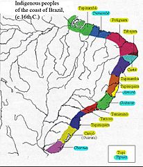
Description: Distribution of indigenous peoples on the coast of Brazil in the 16th C. Yellow = Tupí peoples (inclusive of Guarani), Blue = non-Tupi peoples (Jê-speaking peoples, also known as Tapuia.)
Title: Map of indigenous peoples of Brazil (16th C.)
Credit: Slide27.JPG
Author: Slide27.JPG: Epalitot derivative work: Walrasiad (talk)
Usage Terms: Creative Commons Attribution-Share Alike 3.0
License: CC BY-SA 3.0
License Link: https://creativecommons.org/licenses/by-sa/3.0
Attribution Required?: Yes
Image usage
The following 2 pages link to this image:

All content from Kiddle encyclopedia articles (including the article images and facts) can be freely used under Attribution-ShareAlike license, unless stated otherwise.
.jpg)