
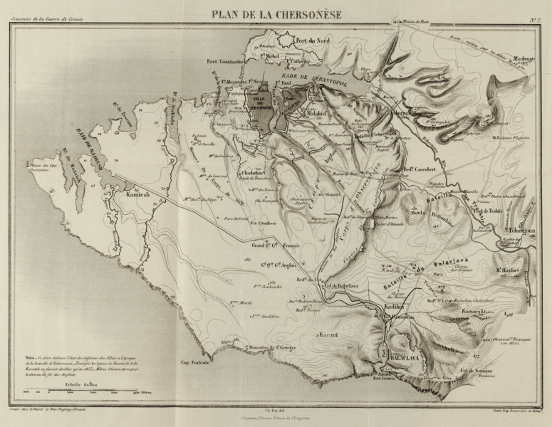
Image: Map of port of Balaklava and route to Sevastopol 1855

Description: Plan de la Chersonèse by Capitaine Charles Alexandre Fay, French staff officer. Published 1867 by J Dumaine, Imperial Librarian, Paris. Map of Chersonèse showing the routes between the port of Balaklava and the Siege of Sevastopol (1854–1855), including the Grand Crimean Central Railway. Scaled to 35% of original
Title: Map of port of Balaklava and route to Sevastopol 1855
Credit: Library of Congress: source file linked below
Author: Charles Alexandre Fay
Permission: This work is in the public domain in its country of origin and other countries and areas where the copyright term is the author's life plus 70 years or less. You must also include a United States public domain tag to indicate why this work is in the public domain in the United States. Note that a few countries have copyright terms longer than 70 years: Mexico has 100 years, Jamaica has 95 years, Colombia has 80 years, and Guatemala and Samoa have 75 years. This image may not be in the public domain in these countries, which moreover do not implement the rule of the shorter term. Côte d'Ivoire has a general copyright term of 99 years and Honduras has 75 years, but they do implement the rule of the shorter term. Copyright may extend on works created by French who died for France in World War II (more information), Russians who served in the Eastern Front of World War II (known as the Great Patriotic War in Russia) and posthumously rehabilitated victims of Soviet repressions (more information). This file has been identified as being free of known restrictions under copyright law, including all related and neighboring rights.
Usage Terms: Public domain
License: Public domain
Attribution Required?: No
Image usage
The following 4 pages link to this image:
