
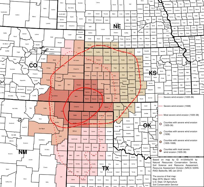
Image: Map of states and counties affected by the Dust Bowl, sourced from US federal government dept. (NRCS SSRA-RAD)

Description: Based only on that PNG image. I made this file primarily using QGIS, and the following public domain [ https://www.census.gov/geo/maps-data/data/tiger-cart-boundary.html shapefiles from census.gov]: cb_2015_us_state_20m cb_2015_us_county_5m The map projection is: NAD83(2011) / Texas Centric Albers Equal Area +proj=aea +lat_1=27.5 +lat_2=35 +lat_0=18 +lon_0=-100 +x_0=1500000 +y_0=6000000 +ellps=GRS80 +units=m +no_defs The original PNG, rotated and scaled slightly to fit this version of the Albers EA projection, is in the image for your comparison. The approximated areas of the Dust Bowl were traced from the PNG in InkScape, no shapefile was made or used. This is definitely the current crown jewel of my Wikipedia images. It took the longest to research and make and it took lots of software. But it was definitely worth it - this map has been requested by readers of w:en:Dust Bowl three times. Someone had to deliver eventually.
Title: Map of states and counties affected by the Dust Bowl, sourced from US federal government dept. (NRCS SSRA-RAD)
Credit: Based on map by ID m12545a/55 by Natural Resources Conservation Service, Soil Science and Resource Assessment, Resource Assessment Division (NRCS SSRA- RAD) Baitsville, MD Jan 2012 The source of that map: Map 2579, March 1954, U.S. Dept. Of Agriculture Soil Conservation Service https://www.nrcs.usda.gov/wps/portal/nrcs/detail/national/about/history/?cid=stelprdb1049437
Author: Soil Science and Resource Assessment, Resource Assessment Division (NRCS SSRA-RAD) (Division of the U.S. Dept. Of Agriculture)
Usage Terms: Public domain
License: Public domain
Attribution Required?: No
Image usage
The following 6 pages link to this image:

.svg)