
Image: Map of the Rancho San Pedro finally confirmed to Manuel Dominguez et al., December 1859 (sc hwmc000790001)

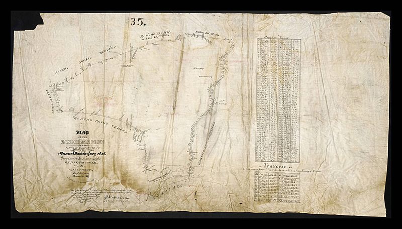
Description: Map of the Rancho San Pedro finally confirmed to Manuel Dominguez et al., December 1859 Hand drawn map on linen by deputy surveyor Henry Hancock showing the course of San Gabriel River from Pacific Ocean and Inner Bay of San Pedro, Rancho Sausal Redondo, Rancho Taujita or Los Cuervos, Rancho San Antonio, Rancho Palos Verdes, and Rancho Las Sierritas. Also shows a table of boundry lines and a table of traverse of the Inner Bay of San Pedro to be excluded from survey of claims. Map number 35. Note: Henry Hancock was a prominent Los Angeles lawyer and surveyor. He worked as Los Angeles City Surveyor and United States Deputy Surveyor in the 1850s. Hancock surveyed most of the large ranches between Monterey and San Diego in California. Physical Description: 1 sheet; 18.5 x 33 in.
Title: Map of the Rancho San Pedro finally confirmed to Manuel Dominguez et al., December 1859 (sc hwmc000790001)
Credit: http://digitalcollections.lmu.edu/cdm/ref/collection/hwmaps/id/165
Author: Hancock, Henry, 1822-1883
Usage Terms: Public domain
License: Public domain
Attribution Required?: No
Image usage
The following 2 pages link to this image:

.jpg)