
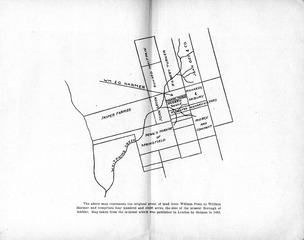
Image: Map of the original grant of land from William Penn to William Harmer, now Ambler, Pennsylvania

Size of this JPG preview of this TIF file: 760 × 599 pixels. Other resolution: 304 × 240 pixels.
Original image (3,134 × 2,472 pixels, file size: 14.8 MB, MIME type: image/tiff)
Description: The above map represents the original grant of land from William Penn to William Harmer and comprises four hundred and eight acres, the size of the present Borough of Ambler. Map taken from the original which was published in London by Holmes in 1682.
Title: Map of the original grant of land from William Penn to William Harmer, now Ambler, Pennsylvania
Credit: http://digital.library.upenn.edu/women/hough/ambler/ambler.html Early history of Ambler, 1682-1888. By Mary Paul Hallowell Hough, 1858-1941. Ambler, PA: H. H. Kelly, 1936. Copyright not renewed.
Author: Mary Paul Hallowell Hough, 1858-1941
Usage Terms: Public domain
License: Public domain
Attribution Required?: No
Image usage
The following page links to this image:

All content from Kiddle encyclopedia articles (including the article images and facts) can be freely used under Attribution-ShareAlike license, unless stated otherwise.