
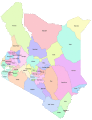
Image: Map showing Counties underthe new kenyan constitution.

Size of this preview: 462 × 599 pixels. Other resolutions: 185 × 240 pixels | 620 × 804 pixels.
Original image (620 × 804 pixels, file size: 56 KB, MIME type: image/gif)
Description: Areas that are covered by Counties in the new Kenya constitution
Title: Map showing Counties underthe new kenyan constitution.
Credit: https://opendata.go.ke/facet/counties
Author: Kenya Open Data Project
Usage Terms: Copyrighted free use
License: Copyrighted free use
License Link: //commons.wikimedia.org/wiki/File:Map_showing_Counties_underthe_new_kenyan_constitution..gif
Image usage
The following page links to this image:

All content from Kiddle encyclopedia articles (including the article images and facts) can be freely used under Attribution-ShareAlike license, unless stated otherwise.