
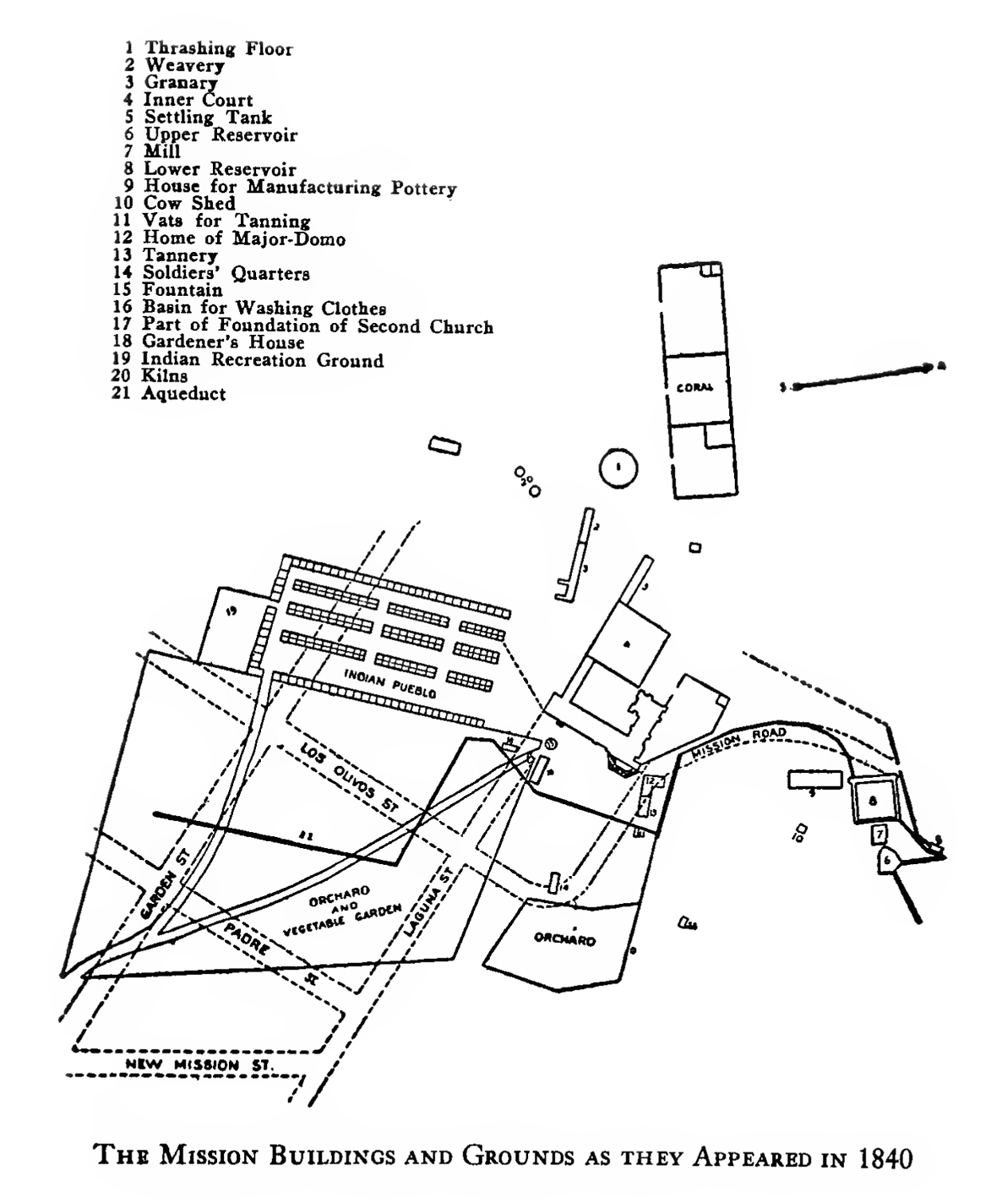
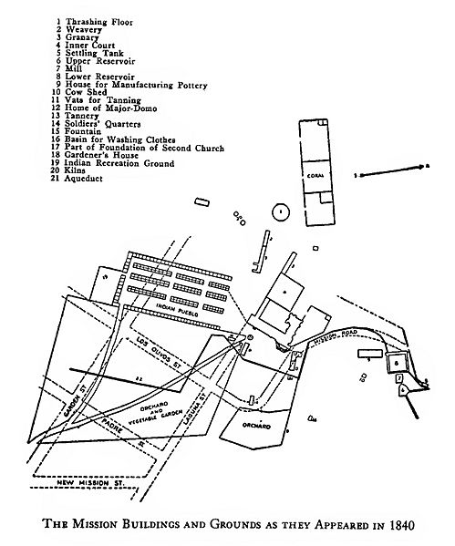
Image: Map showing the arrangement of the Mission Santa Barbara in 1840, ca.1920 (CHS-8950)
Description: Photograph of a map showing the arrangement of the Mission Santa Barbara in 1840, ca.1920. An architectural line drawing of the general outlay of the mission is pictured, showing major roads and the location of twenty-one features of the mission. Picture file card lists the map as coming from the book "Early Days of Santa Barbara" by Walter A. Hawley, published in 1920.; The roads shown are: Mission Road, Los Olvios Street, Garden Street, Padre Street, Laguna Street, and New Mission Street. The features listed and shown are: Thrashing Floor, Weavery, Granary, Inner Court, Settling Tank, Upper Reservoir, House for Manufacturing Pottery, Cow Shed, Vats for Tanning, Home of Major-domo, Tannery, Soldiers' Quarters, Fountain, Basin for Washing Clothes, Part of Foundation of Second Church, Gardener's House, Indian Recreation Ground, Kilns, and Aqueduct. Filename: CHS-8950 Coverage date: circa 1920 Creator: Hawley, Walter A., compiler Photographer: Pierce, C.C. (Charles C.), 1861-1946 Part of collection: California Historical Society Collection, 1860-1960 Part of Subcollection: Title Insurance and Trust, and C.C. Pierce Photography Collection, 1860-1960 Format: 1 photograph : photoprint, b&w ; 26 x 21 cm. Type: images, maps Geographic subject (city or populated place): Santa Barbara; California Repository name: USC Libraries Special Collections Accession number: 8950 Microfiche number: 1-144-151 Archival file: chs_Volume104/CHS-8950.tiff Part of subcollection: Title Insurance and Trust, and C.C. Pierce Photography Collection, 1860-1960 Repository address: Doheny Memorial Library, Los Angeles, CA 90089-0189 Geographic subject (country): USA Format (aacr2): 1 photograph : photoprint, b&w ; 26 x 21 cm. Rights: Public Domain. Release under the CC BY Attribution license -- https://creativecommons.org/licenses/by/3.0/ -- Credit both “University of Southern California. Libraries” and “California Historical Society” as the source. Digitally reproduced by the USC Digital Library; From the California Historical Society Collection at the University of Southern California Call number: CHS-8950 Project: USC Repository email: specol@usc.edu Contributing entity: California Historical Society Date created: circa 1920 Publisher (of the digital version): University of Southern California. Libraries Format (aat): photographic prints; photographs; maps Geographic subject (state): California Subject (file heading): Mission Santa Barbara Legacy record ID: chs-m18907; USC-1-1-1-14095 Access conditions: Send requests to address or e-mail given. Phone (213) 821-2366; fax (213) 740-2343. Geographic subject (county): Santa Barbara Geographic subject (roadway): Mission Road, Los Olvios Street, Garden Street, Padre Street, Laguna Street, and New Mission Street Subject (lcsh): Missions, Spanish Subject (adlf): religious facilities Subject: Santa Barbara Mission
Title: Map showing the arrangement of the Mission Santa Barbara in 1840, ca.1920 (CHS-8950)
Credit: http://cdm15799.contentdm.oclc.org/cdm/singleitem/collection/p15799coll65/id/18740/
Author: Walter Augustus Hawley
Usage Terms: Public domain
License: Public domain
Attribution Required?: No
Image usage
The following page links to this image:

.jpg)