
Image: Mappa mundi Hereford 1300 explained
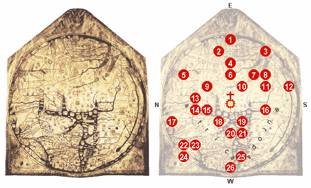
Description: File:Hereford Mappa Mundi 1300.jpg, edited, some details explained. 0 - At the center of the map: Jerusalem, above it: the crucifix. 1 - The Paradise, surrounded by a wall and a ring of fire. 2 - The Ganges and its delta. 3 - The fabulous Island of Taphana, sometimes (possibly mis-)interpreted as Sri Lanka or Sumatra. 4 - Rivers Indus and Tigris. 5 - The Caspian Sea, and the land of Gog and Magog 6 - Babylon and the Euphrat. 7 - The Persian Gulf. 8 - The Red Sea (painted in Red). 9 - Noah's Ark. 10 - The Dead Sea, Sodom and Gomorrha, with River Jordan, coming from Sea of Galiliee; above: Lot's wife. 11 - Egypt with the River Nile. 12 - River Nile [?], or possibly an allusion to the equatorial Ocean; far outside: a land of freaks, possibly the Antipodes. 13 - The Azov Sea with Rivers Don and Dnjepr; above: the Golden Fleece. 14 - Constantinoples; left of it the Danube's delta. 15 - The Aegean Sea. 16 - Oversized delta of the Nile with Alexandria's Lighthouse. 17 - A person skiing [?]. 18 - Greece with Mt. Olymp, Athens and Corinth 19 - Misplaced Crete with Minotaur's circular labyrinth. 20 - The Adriatic Sea; Italy with Rome, honored by a popular heptameter: Roma caput mundi tenet orbis frena rotundi [Rome, the head, holds the reins of the world]. 21 - Sicily, and Carthage, opposing Rome, right of it. 22 - Scotland. 23 - England. 24 - Ireland. 25 - The Baleares. 26 - The Strait of Gibraltar (the Pillars of Hercules).
Title: Mappa mundi Hereford 1300 explained
Credit: File:Hereford Mappa Mundi 1300.jpg, notes in: 1.; 2.; 3.; [1].
Author: WolfgangW.
Usage Terms: Creative Commons Attribution-Share Alike 3.0
License: CC-BY-SA-3.0
License Link: http://creativecommons.org/licenses/by-sa/3.0/
Attribution Required?: Yes
Image usage
The following page links to this image:
